
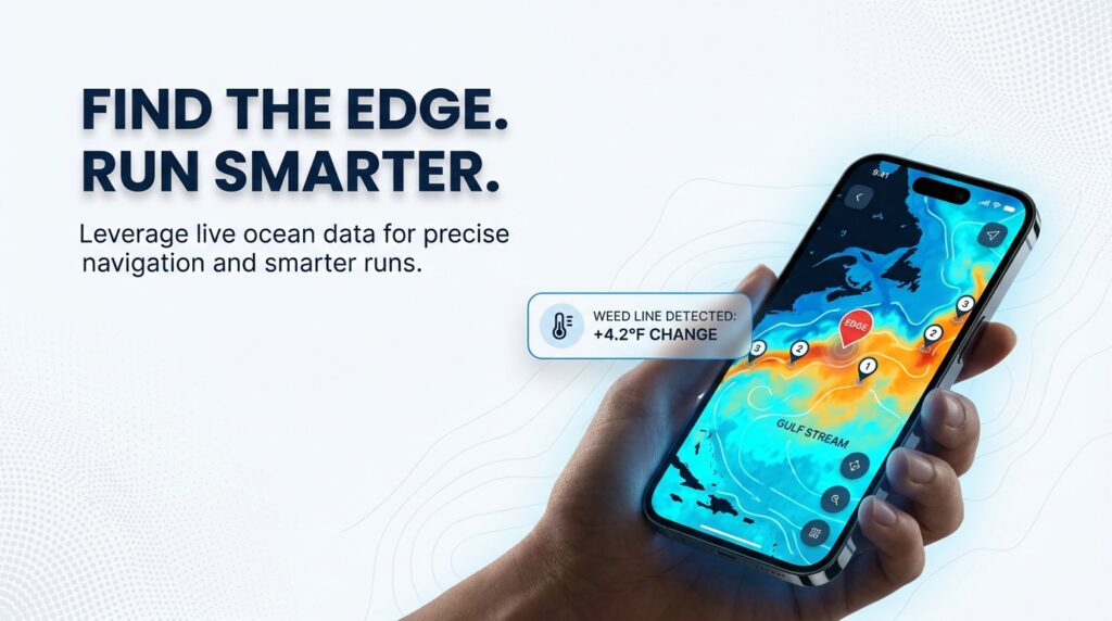
A captain leaving the dock at first light has one real question: which direction to run. Fuel isn’t free, the tide doesn’t wait, and a wrong guess costs the whole morning. This guide is about that one decision: where to look for mahi in the Florida Keys.
NOAA Fisheries identifies Atlantic mahi mahi as Coryphaena hippurus. Dolphinfish, dorado, and mahi mahi are the same fish, and none of them are the marine mammal. What follows covers when to go, what to tie, where to run, and how to read the water once you’re out there. None of it guarantees fish. It should help you burn less fuel finding out.
Why the Keys Sit on the Edge
Mahi mahi are a pelagic, warm-water species that follow warm Gulf Stream western edge water northward each spring. The Keys sit directly on that edge, which is a big part of why they rank among the world’s premier destinations for this species.
The mechanism is straightforward: warm Gulf Stream water carries baitfish, mahi follow the bait, and the Keys happen to sit where that current runs closest to shore. That creates a temperature break, a current line, and a concentration of bait, often within a band just 7 to 12 miles from the beach. That distance is the difference between a short run and a long one.
- Migration driver: warm Gulf Stream water pushes north each spring, and mahi ride it
- Location advantage: the Keys sit on the Stream’s western edge, closer to that current than most of the Florida coast
- Practical distance: fish are commonly found roughly 7 to 12 miles offshore
- What it means for planning: seasonality, temperature, weed lines, and structure all trace back to this one current
Mahi mahi, dolphinfish, and dorado are three names for the same fish, used interchangeably depending on region and angler. It’s not related to the marine mammal despite the shared common name.
When to Go: Mahi Season in the Florida Keys
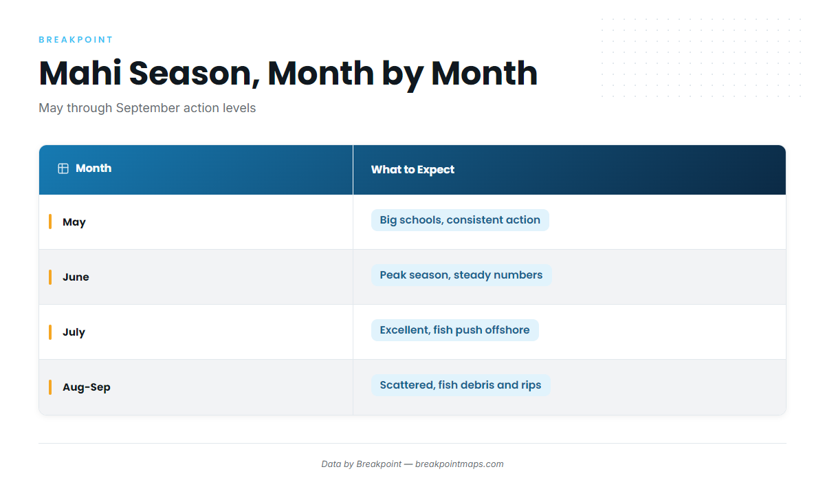
Peak Keys mahi fishing runs late spring through summer, with May and June the most consistent stretch of the year. If you can only plan around one window, that’s it.
Fishingbooker puts the best Keys mahi fishing from April through August, with the most consistent action in May and June. Good Karma Sportfishing agrees on the core of it, calling May through June the highest-volume period as the annual migration peaks. Sources diverge on the season’s edges — one gives April through September, another gives May through October — but both agree on the middle.
If you’re traveling in to fish, the short answer is May or June. If you’re running trips all season as a captain, the nuance matters more: fish push farther offshore as the water warms through July, which changes how far you run, not whether you go.
Month-by-Month Seasonality Table
| Month | What to Expect |
|---|---|
| May | Big schools and consistent action. One of the best months of the year to target mahi. |
| June | Peak season. Steady numbers, good weather, plenty of lifters and gaffers. |
| July | Still excellent, but fish push farther offshore as the water heats up. |
| August | Fishable but more scattered. Best around debris, rips, and strong weed lines. |
| September | Similar to August: scattered fish, with debris and weed lines doing the heavy lifting. |
Where to Look: Reading the Water
Plan to run roughly 7 to 12 miles offshore from the Keys to find mahi, near the reading the Gulf Stream edge. Once you’re out there, the fish give themselves away through a short list of visible cues: diving birds, floating debris, and sargassum weed lines. All three point to the same thing — baitfish concentrated in one spot, with gamefish feeding underneath.
- Distance to fish: roughly 7 to 12 miles offshore, near the shoreward edge of the Gulf Stream
- Primary visual cues: diving birds, floating debris, sargassum weed lines
- What the cues indicate: baitfish concentration, which draws feeding mahi below the surface
- Decision to make: whether a cue is worth a fuel-burning detour, or a false read
The Weed Line: Blue Side vs. Green Side
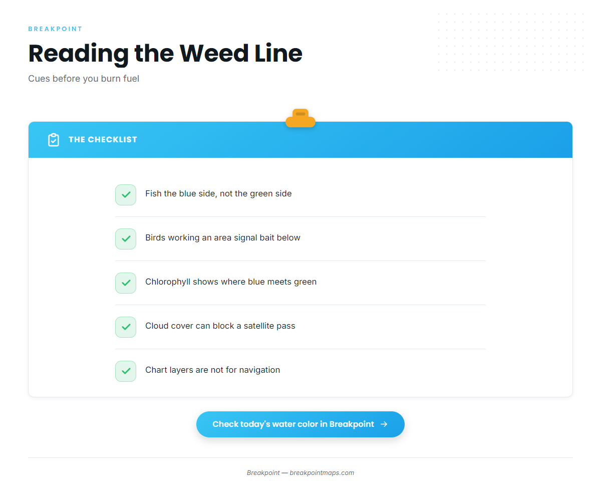
Not all sides of a weed line fish the same. The blue side outfishes the green side, and birds actively working an area indicate bait pinned to the surface by feeding fish below.
Water color is a planning tool, not just scenery. Chlorophyll data acts as a proxy for water color and edges, showing you where blue water meets green before you burn fuel looking for it visually. The limit is real: satellite passes can be blocked by cloud, and chart layers like this aren’t for navigation. They tell you where to look, not where to steer.
Floating Structure and Debris
Logs, pallets, and other debris act like fish magnets, pulling in baitfish and the mahi that feed on them. Mahi will shelter under almost anything floating — pallets, milk jugs, dead palm fronds, buoy lines. Structure like this is worth a 20-minute detour, even if it looks unremarkable from a distance.
Reading the Birds
One to three large frigate birds often mark a small set of big mahi. Deciding whether a sighting is worth the fuel is a skill Keys captains build over years on the water. The difference comes down to speed and elevation: mahi rarely swim faster than about 6 knots unless actively chasing flying fish, so birds moving at something like 20 mph are migrating, not feeding, and aren’t worth chasing.
Humps and Structure
After the run offshore, most mahi charters settle in to work weed lines, current edges, and known structure such as humps and FADs (fish aggregating devices). These features hold fish more reliably than open water, which is why captains build a route around them rather than trolling blind.
Chart Contours is the layer for seeing bottom structure and humps when planning a detour to known terrain. As with every chart layer in this guide, it’s a planning tool, not a navigation tool.
Water Temperature: The Break That Triggers the Bite
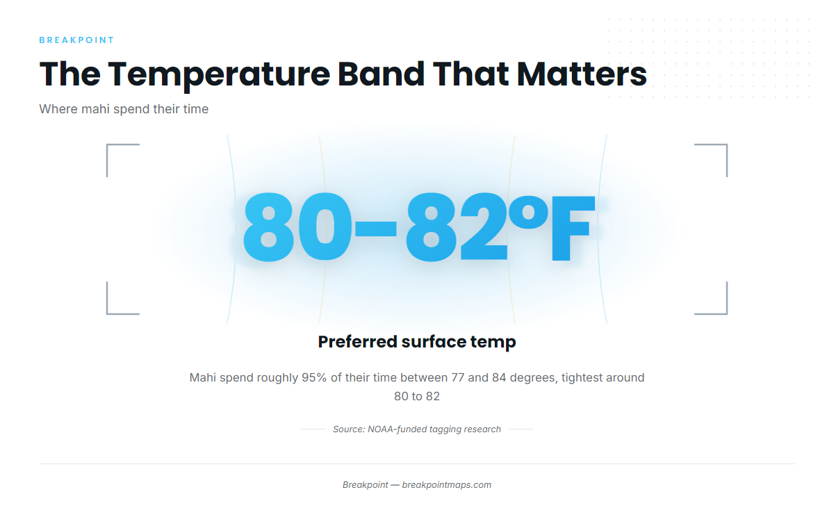
NOAA-funded tagging research shows mahi spend roughly 95% of their time in surface water between 77 and 84 degrees, preferring the NOAA-funded tagging research band of 80 to 82 degrees. That tight number tells you not just that warm water matters, but which warm water matters most.
An SST break is a sharp change in sea surface temperature over a short distance, often where fish stack up because bait does. The OBS SST layer shows the day’s actual observed temperature, letting you find that edge before you leave the dock rather than discovering it forty minutes into a run. The honest limit: a forecast is a forecast, and cloud cover can block a satellite pass on any given day.
Check the Water Before You Run
Before deciding which direction to run, pull up the day’s OBS SST and Chlorophyll layers in Breakpoint and see where the temperature break and the water color line up. It won’t tell you where the fish are. It will tell you where to start looking, which is the difference between a targeted run and a guess — and often the difference in fuel burned finding out.
Rigs and Tackle
The go-to setup for Keys mahi is a rigged ballyhoo trolled behind a modest, purpose-built outfit. Everything else, from trophy tackle to pitch-bait technique, builds from that starting point.
Beginner Setup
A 6-foot stand-up rod paired with a conventional reel in the 30 to 50 pound class covers most Keys mahi fishing. For lure color, a blue-and-white Ilander rigged with ballyhoo is a proven combination that mimics a flying fish, one of mahi’s preferred foods. Pink, purple-and-black, and green-and-yellow round out the productive color list.
Tackle Spec Table
| Setup Level | Rod Class | Reel | Line |
|---|---|---|---|
| Beginner | 6-foot stand-up rod | Conventional reel, 30 to 50 lb class | Standard mono or braid, per reel spec |
| Trophy (targeting larger bulls) | trophy mahi tackle setup 20 to 30 lb class trolling or stand-up rods | Shimano Talica 16 or 20 | Braid with a mono topshot |
How to Rig a Ballyhoo (Pitch Bait)
A pitch-bait ballyhoo rig built the right way holds up under repeated casts to a school:
- Tie a short Bimini twist at the end of your main line to create a doubled section for strength.
- Join the Bimini to your leader with a Bristol knot, connecting it to about 4 feet of 50 pound-test fluorocarbon leader.
- Attach an 8/0 live-bait-style hook to the leader using a loop knot, which lets the hook swing freely.
- Rig the ballyhoo by running the hook point underneath the bait and out through its jaws, so it swims naturally when pitched or trolled.
Setting a Basic Trolling Spread
A simple, effective spread for a small center console doesn’t require a tackle locker full of gear:
- Run rigged ballyhoo on your flat lines, close to the boat, as your primary presentation.
- Add skirted baits on the outriggers for extra flash and color at a wider spread.
- Deploy a teaser or dredge near the boat to draw fish up and into the spread.
- Stagger depths across the spread so you’re covering more of the water column rather than presenting every bait at the same level.
Techniques and Trolling Speeds
Troll rigged ballyhoo at 6.5 to 7.5 knots, and troll skirted lures at 7.5 to 9 knots. Those two ranges cover most Keys trolling situations. Take Me Fishing gives a lighter alternate range of about 5 to 7 knots for skirted lures, worth keeping in mind as a starting point in different conditions. The practical takeaway: slow toward the bottom of the range in rough seas to keep baits swimming cleanly, and push toward the faster end when covering open water with no fish sign.
Trolling Speed by Bait Type Table
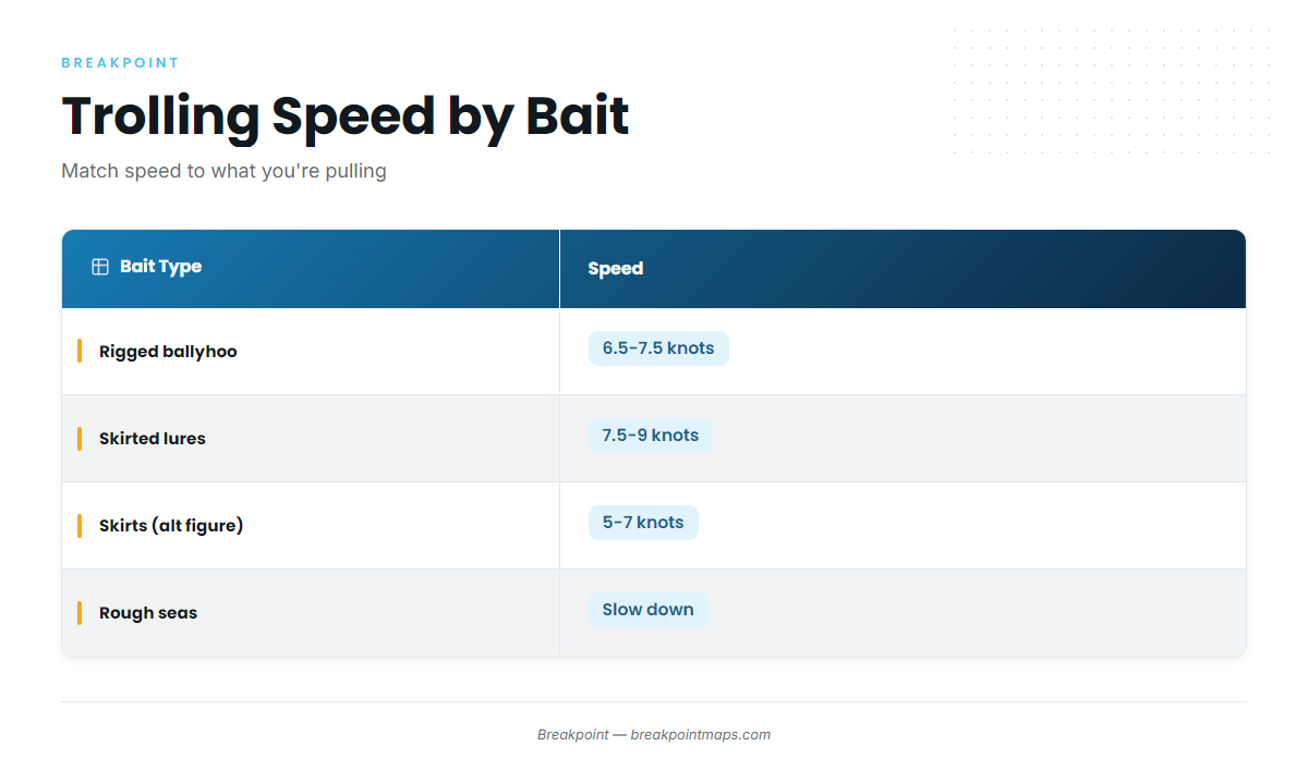
| Bait Type | Recommended Speed | Source |
|---|---|---|
| Rigged ballyhoo | 6.5 to 7.5 knots | Good Karma Sportfishing |
| Skirted lures / feathers | 7.5 to 9 knots | Good Karma Sportfishing |
| Skirted lures (alternate figure) | About 5 to 7 knots | Take Me Fishing |
Working a School: Pitch Baits
Once you raise a school, pitch baits take over from trolling. Cast underhand, six to eight feet ahead of the fish, and let the bait fall naturally into their path. Mahi typically eat on the drop, not on a retrieve. One conservation-minded habit worth adopting: keep one hooked mahi in the water at all times while you work the rest of the school. It holds the group near the boat and extends your window on that school considerably.
Bull vs. Cow
Not every mahi in a school looks the same, and the difference is worth knowing before you decide which fish to target.
- Bulls: males with a square, vertical forehead, often 20 to 50-plus pounds, usually solitary or found in pairs
- Cows: females with a rounded, sloped head, tend to school together, and are the fish you typically find holding on weed lines
The Checklist: Cues Before and On the Water
Before you commit to a direction, run through this short list:
- Temperature break in the 77 to 84 degree range, targeting the 80 to 82 band where mahi spend most of their time
- Blue water meeting green, a visible edge worth working
- A defined weed line, fished from the blue side
- Floating debris, worth a detour even if it looks unremarkable
- Frigate birds moving at a reasonable pace, not migrating birds cruising at something like 20 mph
Regulations: Verify Before You Fish
Reliable bag and size limits for mahi mahi didn’t surface in our research, so we’re not printing numbers we can’t source. Verify current bag and size limits with the Florida Fish and Wildlife Conservation Commission before you fish. We checked for this information on 2026-09-17, and rules change, so confirm current regulations before your trip.
The conservation habit from earlier is worth repeating here: leave one hooked mahi in the water while you work the rest of a school. It keeps the school together and gives you a better, longer shot at the fish already in front of you.
How Breakpoint Turns This Into a Daily Decision
Everything in this guide — the temperature band, the weed line color, the birds, the structure — is information the ocean gives away for free. The problem has never been the data itself. It’s that the data is scattered across satellite portals, buoy pages, and chart formats built for scientists rather than for someone deciding whether to run 40 miles at 5 a.m.
Breakpoint’s value is turning that scattered water data into a better daily decision about where to start looking. It doesn’t promise fish. It promises a clearer starting point and less fuel spent finding out you guessed wrong.
Three layers do the specific work described throughout this guide:
- OBS SST shows the day’s actual observed sea surface temperature, so you can find the 80 to 82 degree edge before you leave the dock instead of hunting for it on the water
- Chlorophyll reads water color and edges, helping you spot where blue meets green before you burn fuel checking it visually
- Chart Contours shows humps and bottom structure worth a detour when you’re already offshore and deciding where to spend your remaining time
The same limits apply here as everywhere else in this guide: a satellite pass can be blocked by cloud, a forecast is a forecast, and chart layers are for planning, not navigation.
For a captain running charters, the argument is fuel and time: less blind running means more of the trip spent fishing. For a visiting angler with a limited window, it’s about picking your best day rather than your only day.
See the Day’s Hotspots Before You Leave the Dock
Sargassum lines move, temperature breaks shift day to day, and neither waits for your schedule. Checking Breakpoint’s daily hotspot view before you run gives you a starting edge to work from, rather than a blind search once you clear the reef. It won’t find the fish for you. It will save you the fuel spent looking in the wrong direction.
Conclusion
Finding mahi near the Keys comes down to a short, repeatable sequence: find the Gulf Stream edge, target the 80 to 82 degree band, read the weed line and the birds, run the right bait at the right speed, and verify regulations before you leave the dock. None of it is complicated. It just takes some discipline to check before you run rather than after.
Before your next trip, work through this sequence:
- Check the day’s temperature break and water color to find where the edge sits today, not last week.
- Pick a starting edge based on that data, whether it’s a weed line, a temperature break, or known structure.
- Plan your spread around the conditions you find, adjusting trolling speed for sea state and bait type.
NOAA-funded tagging research puts mahi in that 77 to 84 degree band roughly 95% of the time, with 80 to 82 as the sweet spot. That number is as close to a sure thing as this fishery offers, and even it is a probability, not a guarantee. Data narrows the search. It doesn’t guarantee the fish.
This guide to catching mahi mahi near the Florida Keys comes down to better information, a shorter search, and more time with lines in the water. Check what the water is doing off the Keys today before you decide which way to point the bow. Open Breakpoint, check the day’s OBS SST and Chlorophyll layers, and start your run from a better position than a guess.
Frequently Asked Questions
What is the best month for mahi mahi in the Florida Keys?
May and June are the most consistent months, sitting within a broader April-through-August window. Fish push farther offshore as the water heats up in July, so timing shifts the distance you run more than whether you catch fish at all. Sources: fishingbooker, Good Karma Sportfishing.
How far offshore do you need to run for mahi near the Keys?
Plan on roughly 7 to 12 miles offshore, near the shoreward edge of the Gulf Stream. In many cases, fish are found less than 10 miles out, which keeps the run manageable for most center consoles. Source: fishingbooker.
What trolling speed works best for mahi mahi?
Troll rigged ballyhoo at 6.5 to 7.5 knots and skirted lures at 7.5 to 9 knots. An alternate range of about 5 to 7 knots applies for skirts in some conditions. Slow down in rough seas to keep baits swimming cleanly. Sources: Good Karma Sportfishing, Take Me Fishing.
Should I hire a charter or rent a boat?
For most visitors, a charter is the practical choice. It removes the gear, setup, and search-strategy burden that trips up first-timers, and rods, reels, bait, and tackle are typically included. Sources: Captain Hooks, M&M Fishing Charters.
How much does a Keys mahi charter cost?
Expect a range of about $1,000 to $3,300, averaging roughly $1,396 for a half day and $2,299 for a Keys mahi charter pricing full day. Price varies by boat, crew, and trip length. Source: Captain Experiences.
How long should a mahi trip be?
Six hours is the most flexible option and gives you a real shot offshore. Eight hours offers maximum range and time on the water if your schedule allows it. Source: Two Conchs.